
Lowest to Highest & Hottest to Coldest
We woke up to this view. I love driving in to a hotel at night and seeing how beautiful it’s surrounding area is in the morning.

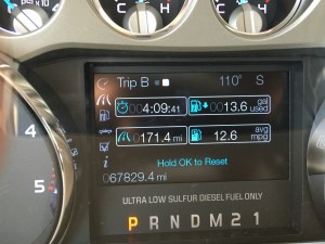
Today’s Stats

At Death Valley we say “The desert is calling and I must go” a refined rewording of the old John Muir quote.
I have to say that is not the way I felt. I couldn’t wait to get out of there.
We drove from Las Vagas to Death Valley National Park and headed straight to the salt flats called Badwater Basin.


Named as such when one of the early frontier explorers noticed their Mule would not drink the water. Interestingly enough the water is not poisoned just really salty. It is also the lowest point in North America at 282 feet below sea level.


We got out of the truck and at 110 degrees the heat was oppressive. On top of that it was really windy. So it was like walking into a convection oven with the blower on. We really only stayed 10 minutes there to get the pictures and get back to the truck, where we left Riley in the AC.
From there we decided to head to Yosemite but we had to get out of Death Valley first. It was up and over some mountains and across a dry lake where the sand storm kicked up throwing sand across the road.
As we were leaving the park we both agreed “been there, done that, don’t need to do it again.” The desert is so bleak and colorless, definitely not our favorite part of the trip but we are glad we can say we did it.
As we drove down the road out of the desert we could see Mt Whitney in front of us. It is the highest point in California at 14,505 feet and is only 85 miles from the lowest point.


Oh yeah we made it to California! But there was no sign to welcome us. As we started our drive north we had never been so excited to see trees. Big beautiful pine tress that we wanted to get out and hug.


We found out the road to Yosemite National Park was closed and also the next mountain road was closed. We ended up taking 89 to State Road 4. It started out beautiful as we slowly wound our way up the side of a mountain.


As we went up we saw snow on the side of the road. So of course we had to stop and play in the snow in flip flops and shorts.


Then we saw this sign. However we were already committed at this point and past the point of no return.
 This is what Wiki has to say about our route.
The route runs through the 8,050 ft (2,450 m). Pacific Grade Summit on its way up to the 8,730 ft (2,660 m) Ebbetts Pass and ends at State Route 89 ten miles (16 km) west of Topaz Lake, on the California–Nevada border. The portion from Arnold to its terminus is designated the Ebbetts Pass Scenic Byway, which is eventually one lane.
Through the mountains, SR 4 is not suitable for large trucks, buses, or RVs, as it becomes very steep and narrow, with no center dividing line shortly after the Mount Reba Turnoff to Bear Valley Ski area, with tight switchbacks. The pass is not plowed for snow, and thus closes during the winter months often from November through as late as May.
So in the black of night we are going through this mountain pass in a vehicle that was way too long and heavy for the road. It was so windy with hair pin turns and switch backs. At one point the tires spun when we went up hill around a sharp curve. We had to watch for oncoming cars and there was barely enough room for them to get by. Needless to say it was about 2 hours of white knuckled, sweaty palms driving.
The snow was piled up 4 feet and the temperature got down to 38 degrees.Travis did an amazing job navigating that road.
It was midnight by the time we got back to civilization and found a hotel with vacancy that took dogs. Phew what a long day! But we ended up an hour from our final destination so we could sleep in the next day.

What others are saying: